Skip navigation links

Buy now

Please purchase all our products from these authorized dealers only to ensure that you receive full support in Warranty and replacement matters.

AQUAMAP® 100xs
Discontinued

AQUAMAP® 100xs

Part Number 010-01190-00

SHOP ONLINE

AQUAMAP® 100xs AQUAMAP® 100xs

10" Keyed Chartplotter/Sonar Combo for Fishing

  • Keyed chartplotter/sonar combo with 10” color SVGA display
  • Preloaded worldwide basemap
  • Built-in Garmin HD-ID™ 1 kW sonar, CHIRP and ClearVü™ scanning sonar with CHIRP technology
  • High-sensitivity internal 10 Hz GPS/GLONASS receiver
  • Supports all Garmin marine radar

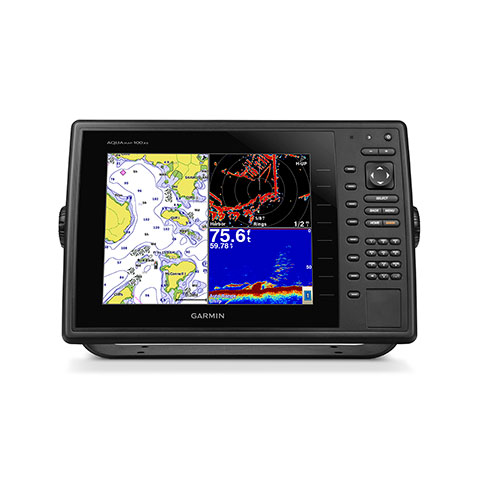
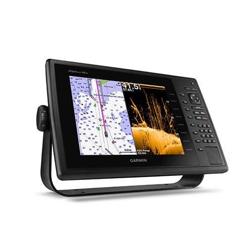
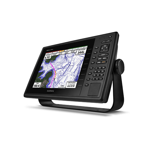
The AQUAMAP 100xs keyed chartplotter/sonar combo has a 10” color SVGA display and comes preloaded with a worldwide basemap. HD-ID, CHIRP and ClearVü with CHIRP sonar technology are built-in allowing you the flexibility to choose from several optional transducers.


Super-fast 10 Hz GPS/GLONASS

High-sensitivit 10 Hz GPS/GLONASS provides position and heading updates 10 times per second (Garmin GA38 is included & required for GPS/Chart-plotter function)


Extreme Sonar Capabilities

The built-in sonar capabilities of the AQUAMAP 100xs gives you the freedom and flexibility to choose from several optional transducers, including traditional, CHIRP and all-in-one HD-ID/ClearVü scanning sonar with CHIRP technology. Add a GCV™ 10 black box sonar for both ClearVü and SideVü™ scanning sonar with CHIRP technology (sold separately).
When used with a compatible CHIRP transducer (sold separately), AQUAMAP 100xs displays crystal-clear sonar images detailing fishing hot spots, ship wreckage or a diving location. With Garmin CHIRP technology, you get remarkable target separation and resolution at extraordinary depths, and can dial into specific frequencies to target certain species of sport fish. Bottom contours are more visible, even at speed, and signal noise can be suppressed at greater depths to provide a more timely interpretation of what’s below for safer navigation and better fishing.


Expand with Radar

Featuring a built-in radar port, AQUAMAP 100xs can be interfaced with Garmin’s line of affordable GMR™ marine radar systems (sold separately). Whether you’re adding radar now or in the future, you’ll enjoy the convenience of plug-and-play installation as well as the power, range and high-definition targeting of our proven radar offerings.


Networking

The AQUAMAP 100xs offers select networking capabilities that allow you to share features with other compatible AQUAMAP units, such as radar, GCV 10 ClearVü and SideVü scanning sonar, supplemental maps, and user data, such as waypoints, routes and tracks.


Special Fishing Features

Supported fishing features include boundary lines and color rejection.

here New Charts Guarantee BlueChart G2 BlueChart G2 Vision LakeVü HD Ultra

Physical & Performance

Unit dimensions, WxHxD 14.1" x 9.3" x 2.9 " (35.9 x 23.6 x 7.5 cm)
Display size, WxH 8.3" x 6.2"; 10.4" diagonal
(21.1 x 15.8 cm; 26.4 cm diagonal)
Display resolution, WxH 800 x 600 pixels
Display type SVGA display
Weight 4.7 lbs (2.1 kg)
Waterproof (IPX7)
Receiver 10 Hz high-sensitivity
Antenna with external connection
Mounting options Bail, flat or flush
Power consumption Max power usage at 10 Vdc: 20 W
Typical current draw at 12 Vdc: 1.7 A
Max current draw at 12 Vdc: 3.8 A

Maps & Memory

Preloaded maps  
Accepts data cards 2 SD™ cards
Waypoints 12,000
Routes 200
Track log 25,000 points; 100 saved tracks

Features & Benefits

Garmin Radar compatible  
Garmin Sonar compatible (built-in) and GCV™ black box compatible
NMEA 2000® compatible  
NMEA 0183 compatible  
Garmin Marine Network™ compatible (limited capabilities)
Garmin SmartMode compatible (customizable monitor presets)  
Supports AIS (tracks target ships position)  
Supports DSC (displays position data from DSC-capable VHF radio)  
Tide tables  
Garmin Meteor Audio System compatible  
Supports Fusion Lync compatible marine radios  
GSD™ Black Box sonar support  
GCV™ Black Box sonar support  
SiriusXM™ Weather & Radio compatible  
BlueChart® Mobile (planning) compatible  
Garmin Helm compatible  
GRID™ (Garmin Remote Input Device) compatible  
Wireless remote compatible  
Wireless mouse compatible  

Sonar Features & Specifications

Dual-frequency (50/200 kHz) sonar capable  
Dual-beam (77/200 kHz) sonar capable  
Frequencies supported 50/77/200 kHz, CHIRP (low, medium, high), ClearVü
Transmit power 1 kW traditional; 1kW CHIRP
CHIRP sonar technology (Built-in)
ClearVü™ with CHIRP (built-in)
SideVü™ (with GCV™ black box, sold separately)
Voltage range 10-32 Vdc input
Maximum depth 1,750 ft @ 50 kHz, saltwater, Garmin dual freq transducer @ 500 W
2,700 ft @ 50 kHz, saltwater, Airmar B260 transducer @ 1000 W
(depth capacity is dependent on water bottom type and other water conditions)
Bottom lock (shows return from the bottom up)  
Water temperature log and graph  
Sonar recording  
Sonar history rewind  

Connections

NMEA 0183 input ports 2
NMEA 0183 output ports 2
Video input ports  
Video output ports  
Wireless connectivity  
Garmin Marine Network™ ports 1


In The Box


  • AQUAMAP 100xs with worldwide basemap
  • Power/data cable
  • Bail mount
  • Flush mount
  • Protective cover
  • Documentation
  • GPS Antenna & Mount Adapter
 
Download the File
 

Software License Agreement

By downloading, installing, or using this software, you agree to be bound by the terms and conditions of the following license agreement. Please read this agreement carefully.

Garmin Corporation ("Garmin") grants you a limited, non-exclusive license to use the upgrade software ("Software") in binary executable form in the normal operation of the applicable Garmin products. Title, ownership rights, and intellectual property rights in and to the Software remain in Garmin. This license is personal to you and you may make copies of the software only for your personal use. You agree that this license agreement does not need to be signed for it to take effect.

The software is provided on an "as is" basis without warranty of any kind — either expressed or implied — including, without limitation, any implied warranties of merchantability or fitness for a particular purpose. Garmin does not warrant the performance of the software or that the software will meet your requirements or operate error free.

You acknowledge that this Software is the property of Garmin and is protected under United States of America copyright laws and international copyright treaties. You further acknowledge that the structure, organization, and code of the Software are valuable trade secrets of Garmin and that the Software in source code form remains a valuable trade secret of Garmin. You agree not to decompile, disassemble, modify, reverse assemble, reverse engineer, or reduce to human readable form the Software or any part thereof or create any derivative works based on the Software.

You agree not to export or re-export the Software to any country in violation of the export control laws of the United States of America.


2018/01/29

AQUAMAP 100xs Software update v3.90

DownloadDownload(113 MB)

AQUAMAP 100xs Software update v3.90

Release Note:

  1. Fix hanging problem while Fantom radar connected
  2. Support manual selection for Airmar transdduers
  3. Fix phonetic keyboard issues
  4. Improve coordinate accuracy while adding new waypoint


How to Update the Software?

  1. Click on 'Download' and choose to save the file to your computer.
  2. Choose a location where you can easily find the file, such as the 'My Documents' folder or 'C:\'.
  3. Once the download is complete, go to the location where you saved the file.
  4. Double-click on the downloaded file. This will automatically extract the files to C:\Garmin and run a program to transfer the software update to an SD card.
  5. Power on the device and make sure all attached network devices are powered on as well.
  6. Insert the card into the card slot of your primary device. Select 'Update Software' in the window that automatically displays. If you do not have a primary device with a card slot, please see your dealer.
  7. After the update completes, all Garmin Marine Network devices and NMEA 2000 sensors will have the latest software. This ensures all of the devices will be able to communicate with each other. Note: If you have additional chartplotters connected to NMEA 2000 and not the Garmin Marine Network, you will have to independently update each chartplotter. After the update of the Garmin Marine Network completes, insert the update card into each NMEA 2000 chartplotter.


NOTE:

This software should only be uploaded to the unit for which it is intended. If this software is uploaded to a GPS unit other than the product it is designed for, it will render the unit inoperative.
If the software upload fails, and subsequent upload attempts prove unsuccessful, the unit may need to be returned to Garmin for service. Call Garmin at +886.2.26429199 ext2 or email Garmin. You may also contact Garmin authorised dealer for product support.
Before proceeding, please back up your waypoints and route data. You may back up the data by copying the GPX files in the Garmin disk to your computer. This software should only be uploaded to the unit for which it is intended. If this software is uploaded to a GPS unit other than the product it is designed for, it will render the unit inoperative.


Change History:

Version 2.20:

  1. Go to the last viewed function after reboot unit.
  2. Not allow using BACK key to get back to home page in Chart, Sonar and Radar pages.
  3. Change Korean font.
  4. Display current position legends while panning the cursor.
  5. Extend AIS/MARPA alarm distance up to 10 miles.
  6. Display legends on "New Route" and "New Boundary" map.
  7. User can hide waypoint symbol on boundary line.
  8. Duplicate duplicate data overlay in overlay number layout settings.
  9. Translation issues.
  10. Increase the waypoints, routes and tracks memory size.
  11. Add Function Mode setting to choose "All", "Sonar Only", and "Radar Only" functions.
  12. Change default chart page as "Navigation Chart".
  13. Add a "Chart Options" in chart menu.
  14. Close the menu window after the setting is applied by "Done" button.
  15. Support keypad handling for English keyboard.
  16. Resize the full screen display window after the menu popup for chart, sonar and Radar page.
  17. Display Gain manual level or Auto word at the display bottom of the left in sonar page.
  18. Combine all radar functions into one offshore mode.
  19. Show Sea Clutter and Rain Clutter information on the left-bottom data window on Radar page.
  20. Adjust the dual range radar menu.
  21. Adjust the vessel position to center in radar overlay.
  22. Add Look Ahead Speed setting in radar overlay menu.
  23. Use the last used waypoint symbol as default when user create the new waypoint.
  24. Bugs fixing.

Version 2.10:

  1. Added Shortcut Key feature.
  2. Supported Sonar Color Rejection.
  3. Supported Dual Range Radar.
  4. Supported Radar MARPA function.
  5. Added Boundary Line feature.

back to top


Loading

Loading